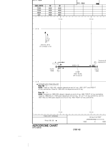


CYBF - Bonnyville
Located in , Canada
ICAO - CYBF, IATA - YBY
Data provided by AirmateGeneral information
Coordinates: N54°18'17" W110°44'28"
Elevation is 1839 feet MSL.
Magnetic variation is 13.2667° East View others Airports in Alberta
Operational data
Special qualification required
Current time UTC:
Current local time:
Weather at : CYOD - Group Captain R.W. Mcnair ( 32 km )
METAR: CYOD 020100Z 02014KT 15SM FEW040 BKN110 07/M01 A2997 RMK SC2AC5 DENSITY ALT 1245FT SLP170
TAF: TAF CYOD 012340Z 0200/0224 02015KT P6SM BKN040 OVC080 TEMPO 0200/0202 P6SM -SHRA OVC030 BECMG 0202/0204 02010KT FM020400 02010KT P6SM FEW040 SCT090 FM021100 02010KT P6SM FEW025 BKN050 FM021500 02015G25KT P6SM -SNRA SCT020 OVC050 TEMPO 0215/0224 3SM -SNRA OVC020 RMK NXT FCST BY 020300Z
Communications frequencies: [VIEW]
Runways:
| RWY identifier | QFU | Length (ft) | Width (ft) | Surface | LDA (ft) |
| 08 | 90° | 4434 | 75 | ASPH | 4434 |
| 26 | 270° | 4434 | 75 | ASPH | 3921 |
Airport contact information
Address: Canada