


CFN7 - Sundre
Located in , Canada
ICAO - CFN7, IATA -
Data provided by AirmateGeneral information
Coordinates: N51°46'29" W114°40'51"
Elevation is 3663 feet MSL.
Magnetic variation is 15.35° East View others Airports in Alberta
Operational data
Special qualification required
Current time UTC:
Current local time:
Weather at : CYQF - Red Deer Regional ( 71 km )
METAR: CYQF 021143Z AUTO 29010KT 6SM BR BKN032 OVC110 01/00 A3002 RMK SLP207
TAF: TAF CYQF 021140Z 0212/0224 32008KT 5SM BR BKN004 OVC030 BECMG 0212/0214 P6SM NSW BKN100 OVC240 FM021700 32012G22KT P6SM SCT080 RMK FCST BASED ON AUTO OBS. NXT FCST BY 021800Z
Communications frequencies: [VIEW]
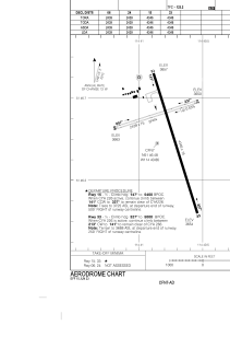
Runways:
| RWY identifier | QFU | Length (ft) | Width (ft) | Surface | LDA (ft) |
| 06 | 72° | 2439 | 75 | GRASS | 2439 |
| 24 | 252° | 2439 | 75 | GRASS | 2439 |
| 15 | 163° | 4346 | 75 | ASPH | 4346 |
| 33 | 343° | 4346 | 75 | ASPH | 4346 |
Airport contact information
Address: Canada