


CED5 - Taber
Located in , Canada
ICAO - CED5, IATA -
Data provided by AirmateGeneral information
Coordinates: N49°49'35" W112°11'5"
Elevation is 2648 feet MSL.
Magnetic variation is 13.6217° East View others Airports in Alberta
Operational data
Special qualification required
Current time UTC:
Current local time:
Weather at : CYQL - Lethbridge ( 49 km )
METAR: CYQL 020500Z AUTO 31010KT 9SM OVC006 02/01 A2989 RMK SLP154
TAF: TAF CYQL 012340Z 0200/0212 30015KT P6SM SCT010 OVC030 TEMPO 0200/0201 4SM -SHRASN BR BKN008 OVC030 FM020100 30015KT P6SM -RA SCT008 OVC030 TEMPO 0201/0209 2SM -SHRASN BR OVC008 FM020900 32015KT 5SM -SNRA SCT006 OVC012 TEMPO 0209/0212 1SM -SHSN BR VV005 RMK NXT FCST BY 020600Z
Communications frequencies: [VIEW]
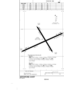
Runways:
| RWY identifier | QFU | Length (ft) | Width (ft) | Surface | LDA (ft) |
| 13 | 148° | 1930 | 75 | ASPH | 1930 |
| 31 | 328° | 1930 | 75 | ASPH | 1930 |
| 05 | 66° | 3005 | 75 | ASPH | 3005 |
| 23 | 246° | 3005 | 75 | ASPH | 3005 |
Airport contact information
Address: Canada