


CDY3 - Fogo
Located in Fogo, Canada
ICAO - CDY3, IATA -
Data provided by AirmateGeneral information
Coordinates: N49°39'27" W54°14'15"
Elevation is 97 feet MSL.
Magnetic variation is -19.91° East View others Airports in Newfoundland and Labrador
Operational data
Special qualification required
Current time UTC:
Current local time:
Weather at : - ( 0 km )
METAR: CYPL 301713Z AUTO 06004KT 040V120 9SM BKN011 BKN018 BKN025 OVC033 02/M00 A2984 RMK SLP127
Communications frequencies: [VIEW]
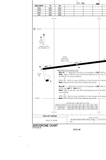
Runways:
| RWY identifier | QFU | Length (ft) | Width (ft) | Surface | LDA (ft) |
| 10 | 83° | 3000 | 75 | ASPH | 3000 |
| 28 | 263° | 3000 | 75 | ASPH | 3000 |
Airport contact information
Address: Fogo Canada