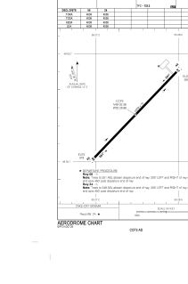


CCP2 - Exploits Valley (Botwood)
Located in , Canada
ICAO - CCP2, IATA -
Data provided by AirmateGeneral information
Coordinates: N49°3'22" W55°26'52"
Elevation is 319 feet MSL.
Magnetic variation is -19.7911° East View others Airports in Newfoundland and Labrador
Operational data
Special qualification required
Current time UTC:
Current local time:
Weather at : CYQX - Gander Intl ( 65 km )
METAR: CYQX 301200Z 02007KT 1/2SM R13/2600V3500FT/U R03/P6000FT/U -DZ BR OVC002 07/07 A2970 RMK FG6ST2 SLP063
TAF: TAF CYQX 301140Z 3012/0112 03006KT 3/4SM -DZ BR VV002 TEMPO 3012/3014 1/4SM FG VV001 BECMG 3012/3014 03012G22KT FM301400 03012G22KT 1SM -DZ BR OVC003 TEMPO 3014/3017 3SM BR OVC007 FM301700 02015G25KT 3SM -DZ BR OVC005 TEMPO 3017/3022 6SM BR OVC010 PROB30 3017/3022 BKN003 FM302200 01015KT 3/4SM -RA BR OVC003 FM010500 06010KT 1/2SM -DZ FG VV001 BECMG 0108/0110 02010G20KT RMK NXT FCST BY 301800Z
Communications frequencies: [VIEW]
Runways:
| RWY identifier | QFU | Length (ft) | Width (ft) | Surface | LDA (ft) |
| 06 | 44° | 4008 | 75 | ASPH | 4008 |
| 24 | 224° | 4008 | 75 | ASPH | 4008 |
Airport contact information
Address: Canada