


CAT4 - Qualicum Beach
Located in , Canada
ICAO - CAT4, IATA - XQU
Data provided by AirmateGeneral information
Coordinates: N49°20'14" W124°23'38"
Elevation is 190 feet MSL.
Magnetic variation is 17.2189° East View others Airports in British Columbia
Operational data
Special qualification required
Current time UTC:
Current local time:
Weather at : CYCD - Nanaimo ( 49 km )
METAR: CYCD 282000Z 23010G21KT 200V280 20SM VCSH FEW038 BKN072 BKN120 13/02 A2997 RMK SC2AC3AC2 SLP152
TAF: TAF CYCD 281744Z 2818/2904 20008KT P6SM SCT040 FM282000 20008G18KT P6SM FEW030 SCT050 TEMPO 2820/2904 P6SM -SHRA SCT030 BKN050 RMK NXT FCST BY 290000Z
Communications frequencies: [VIEW]
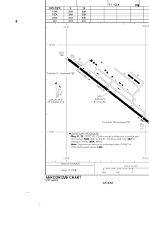
Runways:
| RWY identifier | QFU | Length (ft) | Width (ft) | Surface | LDA (ft) |
| 11 | 128° | 3564 | 75 | ASPH | 3079 |
| 29 | 308° | 3564 | 75 | ASPH | 3364 |
Airport contact information
Address: Canada
