


AYKI - Kiunga
Located in , Papua New Guinea
ICAO - AYKI, IATA - UNG
Data provided by AirmateGeneral information
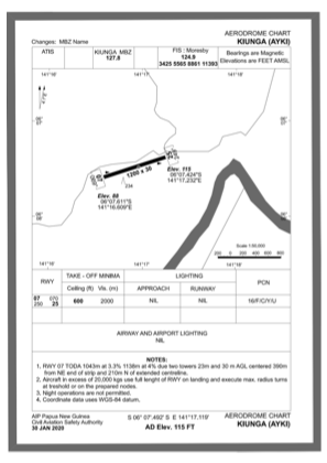
Coordinates: S6°7'29" E141°17'6"
Elevation is 102 feet MSL.
View others Airports in Western (Fly River)
Operational data
Special qualification required
Current time UTC:
Current local time:
Communications frequencies: [VIEW]
Runways:
| RWY identifier | QFU | Length (ft) | Width (ft) | Surface | LDA (ft) |
| 07 | 0° | 3937 | 75 | UNK | |
| 25 | 0° | 3937 | 75 | UNK |
Airport contact information
Address: Papua New Guinea