


AYDU - Daru
Located in , Papua New Guinea
ICAO - AYDU, IATA - DAU
Data provided by AirmateGeneral information
Coordinates: S9°5'12" E143°12'29"
Elevation is 14 feet MSL.
View others Airports in Western (Fly River)
Operational data
Special qualification required
Current time UTC:
Current local time:
Weather at : - ( 0 km )
METAR: NZCM 270331Z AUTO 08010G18KT 030V130 4100 HZ OVC034 M27/M33 A2910 RMK AO2 SNE0331 SLP862 T12711329 $
Communications frequencies: [VIEW]
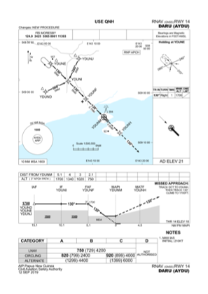
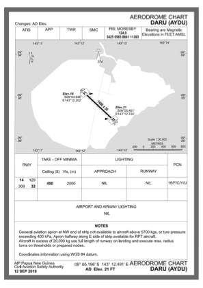
Runways:
| RWY identifier | QFU | Length (ft) | Width (ft) | Surface | LDA (ft) |
| 14 | 135° | 4593 | 98 | ASP | |
| 32 | 315° | 4593 | 98 | ASP |
Airport contact information
Address: Papua New Guinea