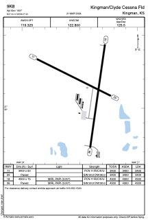


9K8 - Kingman/Clyde Cessna Fld
Located in Kingman, United States
ICAO - 9K8, IATA -
Data provided by AirmateGeneral information
Coordinates: N37°40'8" W98°7'26"
Elevation is 1607 feet MSL.
Magnetic variation is 06° East View others Airports in Kansas
Operational data
Special qualification required
Current time UTC:
Current local time:
Weather at : KHUT - Hutchinson Rgnl ( 50 km )
METAR: KHUT 071652Z 26009KT 10SM CLR 21/03 A2961 RMK AO2 SLP009 T02060028
TAF: KHUT 071724Z 0718/0818 24011KT P6SM SCT250 FM071900 22015G22KT P6SM SCT250 FM080100 16011KT P6SM BKN200 FM080500 25006KT P6SM BKN200 WS020/21035KT FM080900 31008KT P6SM SCT200 FM081200 33012KT P6SM SKC
Communications frequencies: [VIEW]
Runways:
| RWY identifier | QFU | Length (ft) | Width (ft) | Surface | LDA (ft) |
| 11 | 116° | 3400 | 60 | CONC | 3400 |
| 29 | 296° | 3400 | 60 | CONC | 3400 |
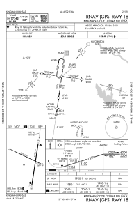
| 18 | 188° | 4300 | 75 | CONC | 4300 |
| 36 | 8° | 4300 | 75 | CONC | 4300 |
Airport contact information
Address: Kingman United States
