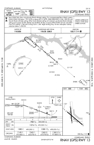


9A4 - Courtland
Located in Courtland, United States
ICAO - 9A4, IATA -
Data provided by AirmateGeneral information
Coordinates: N34°39'29" W87°20'55"
Elevation is 588 feet MSL.
Magnetic variation is -03° East View others Airports in Alabama
Operational data
Special qualification required
Current time UTC:
Current local time:
Weather at : KMSL - Northwest Alabama Rgnl ( 26 km )
METAR: KMSL 282053Z AUTO 15010KT 10SM OVC085 25/17 A3011 RMK AO2 SLP191 T02500167 56017
TAF: KMSL 281723Z 2818/2918 19012G20KT P6SM SCT035 BKN050 FM290000 15010G18KT P6SM FEW200 FM290400 16012G18KT P6SM SCT250 FM290900 16008KT P6SM BKN250 FM291400 18012G20KT P6SM BKN040
Communications frequencies: [VIEW]
Runways:
| RWY identifier | QFU | Length (ft) | Width (ft) | Surface | LDA (ft) |
| 13 | 130° | 4994 | 100 | CONC | |
| 31 | 310° | 4994 | 100 | CONC | |
| 18 | 175° | 3484 | 150 | CONC | |
| 36 | 355° | 3484 | 150 | CONC |
Airport contact information
Address: Courtland United States