


91KS - St Joseph's Landing
Located in St. Mary's, United States
ICAO - 91KS, IATA -
Data provided by AirmateGeneral information
Coordinates: N39°14'32" W96°1'59"
Elevation is 1158 feet MSL.
View others Airports in Kansas
Operational data
Special qualification required
Current time UTC:
Current local time:
Weather at : KTOP - Philip Billard Muni ( 40 km )
METAR: KTOP 072353Z 23007KT 10SM CLR 26/01 A2953 RMK AO2 SLP994 T02610011 10267 20250 50005
Communications frequencies: [VIEW]
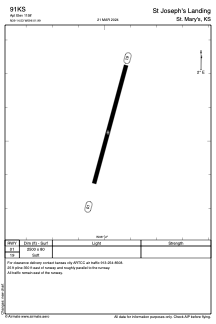
Runways:
| RWY identifier | QFU | Length (ft) | Width (ft) | Surface | LDA (ft) |
| 01 | 15° | 2500 | 80 | GRASS | |
| 19 | 195° | 2500 | 80 | GRASS |
Airport contact information
Address: St. Mary's United States