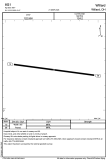


8G1 - Willard
Located in Willard, United States
ICAO - 8G1, IATA -
Data provided by AirmateGeneral information
Coordinates: N41°2'20" W82°43'28"
Elevation is 967 feet MSL.
Magnetic variation is -06° East View others Airports in Ohio
Operational data
Special qualification required
Current time UTC:
Current local time:
Weather at : KMFD - Mansfield Lahm Rgnl ( 30 km )
TAF: KMFD 281739Z 2818/2918 24013G23KT P6SM FEW040 BKN050 BKN070 FM282300 20009KT P6SM FEW250 FM291300 21011KT P6SM FEW250 FM291600 21014G22KT P6SM SCT200
Communications frequencies: [VIEW]
Runways:
| RWY identifier | QFU | Length (ft) | Width (ft) | Surface | LDA (ft) |
| 10 | 97° | 4028 | 65 | ASPH | |
| 28 | 277° | 4028 | 65 | ASPH |
Airport contact information
Address: Willard United States