


83K - Harris
Located in Fort Ann, United States
ICAO - 83K, IATA -
Data provided by AirmateGeneral information
Coordinates: N43°24'35" W73°31'58"
Elevation is 261 feet MSL.
View others Airports in New York
Operational data
Special qualification required
Current time UTC:
Current local time:
Weather at : KGFL - Floyd Bennett Meml ( 10 km )
METAR: KGFL 300730Z AUTO 00000KT 10SM VCTS -RA SCT026 OVC100 08/07 A2999 RMK AO2 LTG DSNT ALQDS P0002 T00830067
TAF: KGFL 300520Z 3006/0106 35004KT P6SM VCTS BKN035CB TEMPO 3006/3008 3SM TSRA BR OVC020CB FM300800 VRB03KT P6SM VCSH BKN015 OVC028 TEMPO 3011/3013 2SM SHRA BR BKN008 OVC018 FM301500 VRB03KT 6SM BR BKN022 OVC040 FM301700 16007KT P6SM SCT028 BKN040 PROB30 3022/3024 3SM TSRA BR OVC015CB FM010000 13004KT 4SM BR VCSH SCT007 OVC015
Communications frequencies: [VIEW]
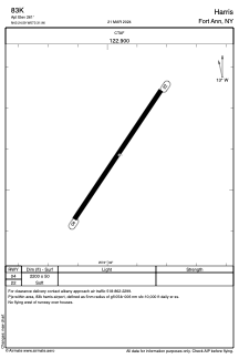
Runways:
| RWY identifier | QFU | Length (ft) | Width (ft) | Surface | LDA (ft) |
| 04 | 34° | 2200 | 50 | GRASS | |
| 22 | 214° | 2200 | 50 | GRASS |
Airport contact information
Address: Fort Ann United States