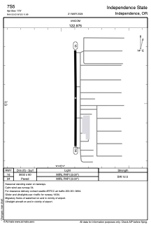


7S5 - Independence State
Located in Independence, United States
ICAO - 7S5, IATA -
Data provided by AirmateGeneral information
Coordinates: N44°52'2" W123°11'54"
Elevation is 180 feet MSL.
Magnetic variation is 19° East View others Airports in Oregon
Operational data
Special qualification required
Current time UTC:
Current local time:
Weather at : KSLE - Mcnary Fld ( 16 km )
TAF: KSLE 022332Z 0300/0324 18003KT P6SM BKN029 OVC035 FM031500 VRB04KT P6SM SCT025 OVC035 FM032200 19008KT 6SM -RA BR OVC025
Communications frequencies: [VIEW]
Runways:
| RWY identifier | QFU | Length (ft) | Width (ft) | Surface | LDA (ft) |
| 16 | 180° | 3002 | 60 | ASPH | |
| 34 | 360° | 3002 | 60 | ASPH |
Airport contact information
Address: Independence United States
