


78NE - Stava
Located in Brainard, United States
ICAO - 78NE, IATA -
Data provided by AirmateGeneral information
Coordinates: N41°9'58" W97°1'53"
Elevation is 1657 feet MSL.
Magnetic variation is 07° East View others Airports in Nebraska
Operational data
Special qualification required
Current time UTC:
Current local time:
Weather at : KAHQ - Wahoo Muni ( 37 km )
METAR: KAHQ 291915Z AUTO 26017G21KT 10SM BKN043 18/08 A2988 RMK AO2 T01810078
Communications frequencies: [VIEW]
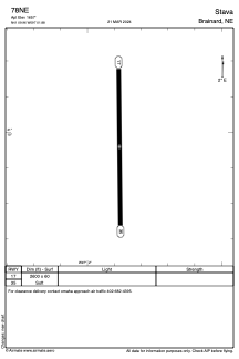
Runways:
| RWY identifier | QFU | Length (ft) | Width (ft) | Surface | LDA (ft) |
| 17 | 179° | 2600 | 60 | GRASS | |
| 35 | 359° | 2600 | 60 | GRASS |
Airport contact information
Address: Brainard United States