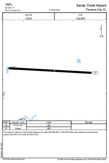


75FL - Sandy Creek Airpark
Located in Panama City, United States
ICAO - 75FL, IATA -
Data provided by AirmateGeneral information
Coordinates: N30°6'10" W85°28'45"
Elevation is 17 feet MSL.
Magnetic variation is -00° East View others Airports in Florida
Operational data
Special qualification required
Current time UTC:
Current local time:
Weather at : KPAM - Tyndall Afb ( 10 km )
METAR: KPAM 030445Z 14003KT 6SM BR CLR 19/18 A2991 RMK AO2A SLPNO $
TAF: TAF KPAM 030300Z 0303/0409 25006KT 9999 FEW010 QNH2994INS BECMG 0304/0305 VRB06KT 4800 BR BKN010 QNH2993INS TEMPO 0311/0313 0800 FG BKN006 BECMG 0312/0313 15009KT 9999 NSW SCT020 QNH2996INS BECMG 0405/0406 VRB06KT 4800 BR BKN008 QNH2997INS TX29/0319Z TN19/0311Z
Communications frequencies: [VIEW]
Runways:
| RWY identifier | QFU | Length (ft) | Width (ft) | Surface | LDA (ft) |
| 09 | 93° | 3175 | 60 | ASPH | |
| 27 | 273° | 3175 | 60 | ASPH |
Airport contact information
Address: Panama City United States