


70S - Mead Flying Service
Located in Mead, United States
ICAO - 70S, IATA -
Data provided by AirmateGeneral information
Coordinates: N47°47'14" W117°21'29"
Elevation is 1905 feet MSL.
Magnetic variation is 19° East View others Airports in Washington
Operational data
Special qualification required
Current time UTC:
Current local time:
Weather at : KSFF - Felts Fld ( 12 km )
METAR: KSFF 040853Z AUTO 08009KT 10SM CLR 13/M03 A2977 RMK AO2 SLP076 T01281028 58019
TAF: KSFF 040523Z 0406/0506 VRB02KT P6SM SKC FM041000 06004KT P6SM BKN120 OVC150 FM041900 08007G14KT P6SM OVC100 FM050000 05007KT P6SM OVC100
Communications frequencies: [VIEW]
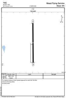
Runways:
| RWY identifier | QFU | Length (ft) | Width (ft) | Surface | LDA (ft) |
| 16 | 180° | 2481 | 30 | ASPH | |
| 34 | 360° | 2481 | 30 | ASPH |
Airport contact information
Address: Mead United States