


6M6 - Lewis County Rgnl
Located in Monticello, United States
ICAO - 6M6, IATA -
Data provided by AirmateGeneral information
Coordinates: N40°7'45" W91°40'42"
Elevation is 675 feet MSL.
Magnetic variation is 01° East View others Airports in Missouri
Operational data
Special qualification required
Current time UTC:
Current local time:
Weather at : KEOK - Keokuk Muni ( 42 km )
METAR: KEOK 070715Z AUTO 13011KT 10SM FEW037 BKN055 OVC065 19/17 A2956 RMK A01
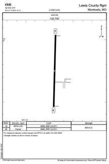
Communications frequencies: [VIEW]
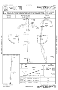
Runways:
| RWY identifier | QFU | Length (ft) | Width (ft) | Surface | LDA (ft) |
| 18 | 181° | 3500 | 60 | CONC | |
| 36 | 1° | 3500 | 60 | CONC |
Airport contact information
Address: Monticello United States