


6B4 - Frankfort-Highland
Located in Utica/Frankfort, United States
ICAO - 6B4, IATA -
Data provided by AirmateGeneral information
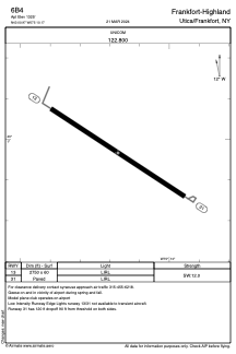
Coordinates: N43°0'58" W75°10'10"
Elevation is 1325 feet MSL.
Magnetic variation is -13° East View others Airports in New York
Operational data
Special qualification required
Current time UTC:
Current local time:
Weather at : KRME - Griffiss Intl ( 31 km )
METAR: KRME 300553Z AUTO 12006KT 10SM FEW075 11/09 A2993 RMK AO2 LTG DSNT NE SLP134 60017 T01110089 10161 20106 58011
TAF: KRME 300558Z 3006/0106 10010KT P6SM BKN060 BKN250 FM300900 11003KT 3SM BR SCT025 BKN050 FM301400 VRB05KT P6SM BKN015 OVC040 FM301800 26006KT P6SM -SHRA OVC012 FM302000 25006KT 3SM SHRA BR OVC008 FM010400 29004KT 3SM BR OVC005
Communications frequencies: [VIEW]
Runways:
| RWY identifier | QFU | Length (ft) | Width (ft) | Surface | LDA (ft) |
| 13 | 123° | 2750 | 60 | ASPH | |
| 31 | 303° | 2750 | 60 | ASPH |
Airport contact information
Address: Utica/Frankfort United States