


67R - Rio Grande City Muni
Located in Rio Grande City, United States
ICAO - 67R, IATA -
Data provided by AirmateGeneral information
Coordinates: N26°25'27" W98°50'46"
Elevation is 290 feet MSL.
Magnetic variation is 07° East View others Airports in Texas
Operational data
Special qualification required
Current time UTC:
Current local time:
Weather at : KMFE - Mc Allen Intl ( 67 km )
METAR: KMFE 011953Z 13021G26KT 10SM BKN036 OVC045 32/23 A2968 RMK AO2 PK WND 14030/1927 SLP049 T03220233
TAF: KMFE 011720Z 0118/0218 13019G27KT P6SM SCT025 BKN035 BKN040 FM020200 14016G24KT P6SM BKN025 FM021200 14012G20KT P6SM BKN010 FM021600 16014G23KT P6SM BKN020
Communications frequencies: [VIEW]
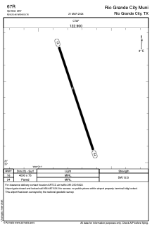
Runways:
| RWY identifier | QFU | Length (ft) | Width (ft) | Surface | LDA (ft) |
| 16 | 162° | 4000 | 75 | ASPH | |
| 34 | 342° | 4000 | 75 | ASPH |
Airport contact information
Address: Rio Grande City United States