


66IL - Aerogrange
Located in Marengo, United States
ICAO - 66IL, IATA -
Data provided by AirmateGeneral information
Coordinates: N42°16'7" W88°34'17"
Elevation is 824 feet MSL.
Magnetic variation is -00° East View others Airports in Illinois
Operational data
Special qualification required
Current time UTC:
Current local time:
Weather at : KDKB - De Kalb Taylor Muni ( 39 km )
METAR: KDKB 291035Z AUTO 13007KT 10SM SCT065 BKN090 OVC110 15/13 A2979 RMK AO2 P0002 T01450129
Communications frequencies: [VIEW]
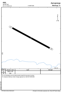
Runways:
| RWY identifier | QFU | Length (ft) | Width (ft) | Surface | LDA (ft) |
| 12 | 118° | 2050 | 100 | GRASS | |
| 30 | 298° | 2050 | 100 | GRASS |
Airport contact information
Address: Marengo United States