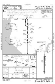
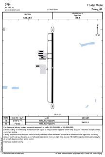


5R4 - Foley Muni
Located in Foley, United States
ICAO - 5R4, IATA -
Data provided by AirmateGeneral information
Coordinates: N30°25'40" W87°42'3"
Elevation is 74 feet MSL.
Magnetic variation is -02° East View others Airports in Alabama
Operational data
Special qualification required
Current time UTC:
Current local time:
Weather at : KJKA - Gulf Shores Intl/Jack Edwards Fld ( 16 km )
METAR: KJKA 282356Z 12011KT 10SM CLR 22/20 A3007
TAF: KJKA 282333Z 2900/2924 11013G19KT P6SM FEW018 FM290200 14010KT P6SM SCT025 BKN250 FM291800 15016G22KT P6SM VCTS BKN050CB
Communications frequencies: [VIEW]
Runways:
| RWY identifier | QFU | Length (ft) | Width (ft) | Surface | LDA (ft) |
| 18 | 180° | 3700 | 74 | ASPH | |
| 36 | 360° | 3700 | 74 | ASPH |
Airport contact information
Address: Foley United States
