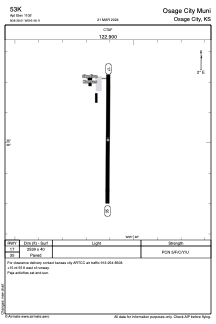


53K - Osage City Muni
Located in Osage City, United States
ICAO - 53K, IATA -
Data provided by AirmateGeneral information
Coordinates: N38°38'1" W95°48'7"
Elevation is 1105 feet MSL.
Magnetic variation is 06° East View others Airports in Kansas
Operational data
Special qualification required
Current time UTC:
Current local time:
Weather at : KFOE - Topeka Rgnl ( 37 km )
METAR: KFOE 070553Z AUTO 10006KT 10SM BKN080 16/11 A2949 RMK AO2 SLP981 6//// T01610111 10228 20156 402280128 53012 $
TAF: KFOE 070520Z 0706/0806 19010KT P6SM SCT110 FM071700 27011G22KT P6SM SKC FM080000 21010KT P6SM SKC
Communications frequencies: [VIEW]
Runways:
| RWY identifier | QFU | Length (ft) | Width (ft) | Surface | LDA (ft) |
| 17 | 180° | 2539 | 40 | ASPH | |
| 35 | 0° | 2539 | 40 | ASPH |
Airport contact information
Address: Osage City United States