


4M2 - Booneville Muni
Located in Booneville, United States
ICAO - 4M2, IATA -
Data provided by AirmateGeneral information
Coordinates: N35°8'58" W93°51'48"
Elevation is 468 feet MSL.
Magnetic variation is 05° East View others Airports in Arkansas
Operational data
Special qualification required
Current time UTC:
Current local time:
Weather at : KFSM - Fort Smith Rgnl (Ebbing Fld Angb) ( 50 km )
METAR: KFSM 051920Z 34010G17KT 2SM R26/6000VP6000FT +RA BR FEW007 BKN022 OVC026 19/18 A2993 RMK AO2 P0018 T01890178
TAF: KFSM 051909Z 0519/0618 08008KT 6SM -SHRA BR VCTS SCT015CB BKN050 OVC100 TEMPO 0519/0522 2SM RA BKN009 FM052200 03006KT 3SM -SHRA BR OVC007 FM060200 VRB03KT 4SM BR OVC007 FM060700 VRB02KT 1 1/2SM BR OVC003 FM061500 18007KT P6SM BKN020
Communications frequencies: [VIEW]
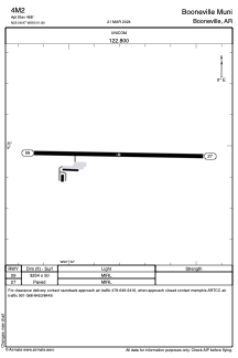
Runways:
| RWY identifier | QFU | Length (ft) | Width (ft) | Surface | LDA (ft) |
| 09 | 91° | 3254 | 50 | ASPH | |
| 27 | 271° | 3254 | 50 | ASPH |
Airport contact information
Address: Booneville United States