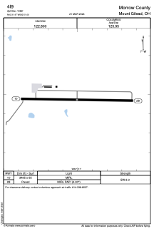


4I9 - Morrow County
Located in Mount Gilead, United States
ICAO - 4I9, IATA -
Data provided by AirmateGeneral information
Coordinates: N40°31'28" W82°51'0"
Elevation is 1086 feet MSL.
Magnetic variation is -08° East View others Airports in Ohio
Operational data
Special qualification required
Current time UTC:
Current local time:
Weather at : KMNN - Marion Muni ( 21 km )
METAR: KMNN 290553Z AUTO 21007KT 10SM CLR 19/14 A3002 RMK AO2 SLP161 T01890139 10256 20178 55001
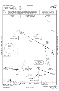
Communications frequencies: [VIEW]
Runways:
| RWY identifier | QFU | Length (ft) | Width (ft) | Surface | LDA (ft) |
| 10 | 91° | 3495 | 65 | ASPH | |
| 28 | 271° | 3495 | 65 | ASPH |
Airport contact information
Address: Mount Gilead United States