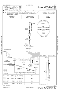
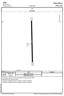


4D9 - Alma Muni
Located in Alma, United States
ICAO - 4D9, IATA -
Data provided by AirmateGeneral information
Coordinates: N40°6'45" W99°20'47"
Elevation is 2073 feet MSL.
Magnetic variation is 05° East View others Airports in Nebraska
Operational data
Special qualification required
Current time UTC:
Current local time:
Weather at : KHDE - Brewster Fld ( 38 km )
METAR: KHDE 292135Z AUTO 24010KT 10SM CLR 21/09 A2983 RMK AO2 T02120088
Communications frequencies: [VIEW]
Runways:
| RWY identifier | QFU | Length (ft) | Width (ft) | Surface | LDA (ft) |
| 17 | 179° | 3200 | 60 | CONC | |
| 35 | 359° | 3200 | 60 | CONC |
Airport contact information
Address: Alma United States