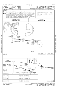


4A4 - Polk County/Cornelius Moore Fld
Located in Cedartown, United States
ICAO - 4A4, IATA -
Data provided by AirmateGeneral information
Coordinates: N34°1'7" W85°8'41"
Elevation is 974 feet MSL.
Magnetic variation is -05° East View others Airports in Georgia
Operational data
Special qualification required
Current time UTC:
Current local time:
Weather at : KPUJ - Paulding Northwest Atlanta ( 22 km )
METAR: KPUJ 022235Z AUTO 18003KT 10SM CLR 28/11 A2997 RMK AO2
Communications frequencies: [VIEW]
Runways:
| RWY identifier | QFU | Length (ft) | Width (ft) | Surface | LDA (ft) |
| 10 | 97° | 5060 | 75 | ASPH | |
| 28 | 277° | 5060 | 75 | ASPH |
Airport contact information
Address: Cedartown United States
