


45K - Minneapolis City County
Located in Minneapolis, United States
ICAO - 45K, IATA -
Data provided by AirmateGeneral information
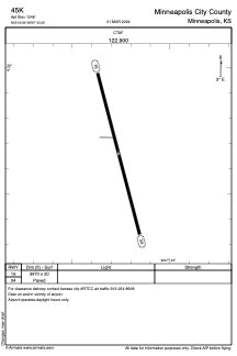
Coordinates: N39°5'40" W97°43'16"
Elevation is 1246 feet MSL.
Magnetic variation is 07° East View others Airports in Kansas
Operational data
Special qualification required
Current time UTC:
Current local time:
Weather at : KSLN - Salina Rgnl ( 34 km )
METAR: KSLN 070753Z AUTO 30003KT 10SM CLR 09/06 A2950 RMK AO2 SLP985 T00940061
TAF: KSLN 070520Z 0706/0806 20004KT P6SM SKC FM071500 28011KT P6SM SKC FM071800 24014G22KT P6SM SKC
Communications frequencies: [VIEW]
Runways:
| RWY identifier | QFU | Length (ft) | Width (ft) | Surface | LDA (ft) |
| 16 | 165° | 3970 | 20 | ASPH | |
| 34 | 345° | 3970 | 20 | ASPH |
Airport contact information
Address: Minneapolis United States