


43D - Odessa Muni
Located in Odessa, United States
ICAO - 43D, IATA -
Data provided by AirmateGeneral information
Coordinates: N47°20'51" W118°40'38"
Elevation is 1738 feet MSL.
Magnetic variation is 19° East View others Airports in Washington
Operational data
Special qualification required
Current time UTC:
Current local time:
Weather at : KMWH - Grant County Intl ( 51 km )
METAR: KMWH 041752Z 01009KT 10SM OVC070 15/06 A2957 RMK AO2 SLP012 60000 T01500056 10150 20133 58013
TAF: KMWH 041737Z 0418/0518 05011KT P6SM OVC070 FM042000 08014KT P6SM OVC090 FM050000 04010KT P6SM OVC080 FM050600 02009KT P6SM -RA OVC060 FM051500 15006KT 6SM -RA BR OVC050
Communications frequencies: [VIEW]
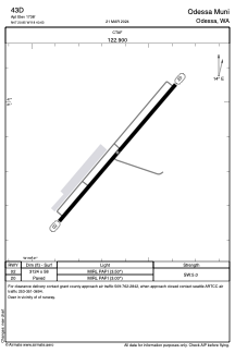
Runways:
| RWY identifier | QFU | Length (ft) | Width (ft) | Surface | LDA (ft) |
| 02 | 41° | 3124 | 58 | ASPH | |
| 20 | 221° | 3124 | 58 | ASPH |
Airport contact information
Address: Odessa United States