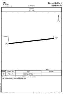


3T3 - Boyceville Muni
Located in Boyceville, United States
ICAO - 3T3, IATA -
Data provided by AirmateGeneral information
Coordinates: N45°2'38" W92°1'17"
Elevation is 967 feet MSL.
Magnetic variation is 00° East View others Airports in Wisconsin
Operational data
Special qualification required
Current time UTC:
Current local time:
Weather at : KLUM - Menomonie Muni/Score Fld ( 21 km )
METAR: KLUM 290735Z AUTO 08009KT 10SM OVC008 07/07 A2979 RMK AO2 T00680067 PWINO
Communications frequencies: [VIEW]
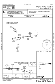
Runways:
| RWY identifier | QFU | Length (ft) | Width (ft) | Surface | LDA (ft) |
| 08 | 84° | 3299 | 60 | ASPH | |
| 26 | 264° | 3299 | 60 | ASPH |
Airport contact information
Address: Boyceville United States