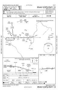
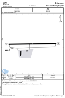


39N - Princeton
Located in Princeton/Rocky Hill, United States
ICAO - 39N, IATA -
Data provided by AirmateGeneral information
Coordinates: N40°23'57" W74°39'32"
Elevation is 128 feet MSL.
Magnetic variation is -13° East View others Airports in New Jersey
Operational data
Special qualification required
Current time UTC:
Current local time:
Weather at : KTTN - Trenton Mercer ( 19 km )
METAR: KTTN 032053Z 12011KT 10SM CLR 14/08 A3017 RMK AO2 SLP210 T01390083 56005
TAF: KTTN 032005Z 0320/0418 12012KT P6SM BKN025 TEMPO 0320/0324 SCT020 FM040100 11008KT P6SM BKN015 FM041500 10008KT P6SM BKN020
Communications frequencies: [VIEW]
Runways:
| RWY identifier | QFU | Length (ft) | Width (ft) | Surface | LDA (ft) |
| 10 | 89° | 3499 | 75 | ASPH | |
| 28 | 269° | 3499 | 75 | ASPH |
Airport contact information
Address: Princeton/Rocky Hill United States
