


22T - Tecumseh Mills
Located in Tecumseh, United States
ICAO - 22T, IATA -
Data provided by AirmateGeneral information
Coordinates: N42°2'2" W83°52'42"
Elevation is 797 feet MSL.
View others Airports in Michigan
Operational data
Special qualification required
Current time UTC:
Current local time:
Weather at : KARB - Ann Arbor Muni ( 24 km )
METAR: KARB 042353Z 13006KT 9SM FEW017 SCT049 OVC060 20/17 A2991 RMK AO2 SLP126 T02000167 10217 20194 58006
Communications frequencies: [VIEW]
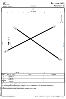
Runways:
| RWY identifier | QFU | Length (ft) | Width (ft) | Surface | LDA (ft) |
| 07 | 63° | 4258 | 75 | ASPH | |
| 25 | 243° | 4258 | 75 | ASPH | |
| 13 | 125° | 4278 | 75 | ASPH | |
| 31 | 305° | 4278 | 75 | ASPH |
Airport contact information
Address: Tecumseh United States