


20N - Kingston-Ulster
Situé à Kingston, United States
ICAO - 20N, IATA -
Données fournies par AirmateInformation générale
Coordonnées: N41°59'7" W73°57'52"
Élévation : 147 feet MSL.
Variation magnétique : -13° East Voir autres Aéroports à New York
Données opérationnelles
Special qualification required
Heure actuelle UTC:
Heure actuelle locale:
Météo à : KPOU - Hudson Valley Rgnl ( 40 km )
METAR: KPOU 170353Z 05003KT 10SM CLR 14/13 A2991 RMK AO2 SLP123 T01390128
TAF: KPOU 170409Z 1704/1724 00000KT P6SM SKC TEMPO 1704/1706 1/2SM FG BKN002 FM170600 VRB02KT 2SM BR SCT002 TEMPO 1706/1710 1/2SM FG BKN002 FM171200 VRB03KT P6SM FEW050 FM171400 04005KT P6SM SCT050 FM171800 08005KT P6SM SCT050 BKN100
Fréquences de communication: [VIEW]
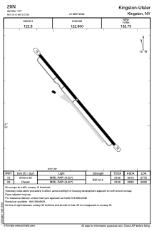
Pistes:
| Identifiant RWY | QFU | Longueur (ft) | Largeur (ft) | Surface | LDA (ft) |
| 15 | 140° | 3100 | 60 | ASPH | 2775 |
| 33 | 320° | 3100 | 60 | ASPH | 2630 |
Coordonnées de l'aéroport
Adresse: Kingston United States
