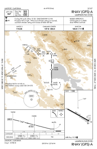
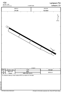


1O2 - Lampson Fld
Located in Lakeport, United States
ICAO - 1O2, IATA -
Data provided by AirmateGeneral information
Coordinates: N38°59'26" W122°54'3"
Elevation is 1380 feet MSL.
Magnetic variation is 16° East View others Airports in California
Operational data
Special qualification required
Current time UTC:
Current local time:
Weather at : KUKI - Ukiah Muni ( 30 km )
METAR: KUKI 032356Z AUTO 29007G15KT 250V320 10SM CLR 23/08 A2986 RMK AO2 SLP105 T02280083 10256 20200 56014
TAF: KUKI 032351Z 0400/0424 28010G20KT P6SM BKN250 FM040300 35008KT P6SM BKN250 FM040500 VRB04KT P6SM SCT035 FM040900 21008KT 3SM RA BR FEW007 OVC020 FM041300 33008KT 4SM -RA BKN015 OVC025
Communications frequencies: [VIEW]
Runways:
| RWY identifier | QFU | Length (ft) | Width (ft) | Surface | LDA (ft) |
| 10 | 119° | 3600 | 60 | ASPH | |
| 28 | 299° | 3600 | 60 | ASPH |
Airport contact information
Address: Lakeport United States