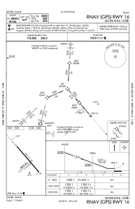
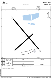


1B0 - Dexter Rgnl
Located in Dexter, United States
ICAO - 1B0, IATA -
Data provided by AirmateGeneral information
Coordinates: N45°0'16" W69°14'15"
Elevation is 533 feet MSL.
Magnetic variation is -18° East View others Airports in Maine
Operational data
Special qualification required
Current time UTC:
Current local time:
Weather at : KBGR - Bangor Intl ( 39 km )
METAR: KBGR 051553Z 16011KT 10SM OVC027 13/07 A3031 RMK AO2 SLP265 T01330067
TAF: KBGR 051120Z 0512/0612 17004KT P6SM OVC026 FM052300 18010G19KT 5SM -RA BR OVC015 FM060000 18010G19KT 3SM -RA BR OVC009 FM060300 18008KT 3SM -RA BR OVC005 FM060800 18007KT P6SM VCSH OVC003
Communications frequencies: [VIEW]
Runways:
| RWY identifier | QFU | Length (ft) | Width (ft) | Surface | LDA (ft) |
| 07 | 49° | 1249 | 120 | GRASS | |
| 25 | 229° | 1249 | 120 | GRASS | |
| 16 | 139° | 3008 | 75 | ASPH | |
| 34 | 319° | 3008 | 75 | ASPH |
Airport contact information
Address: Dexter United States