


19M - C A Moore
Located in Lexington, United States
ICAO - 19M, IATA -
Data provided by AirmateGeneral information
Coordinates: N33°7'32" W90°1'32"
Elevation is 340 feet MSL.
Magnetic variation is 02° East View others Airports in Mississippi
Operational data
Special qualification required
Current time UTC:
Current local time:
Weather at : KGWO - Greenwood-Leflore ( 41 km )
METAR: KGWO 291553Z AUTO 22008KT 10SM BKN100 22/18 A2995 RMK AO2 RAB28E37 SLP140 P0000 T02220178
TAF: KGWO 291157Z 2912/3012 17010G21KT 6SM RA BR VCTS SCT025CB BKN100 FM291600 16012G25KT P6SM BKN015 OVC023 FM292000 18012G20KT P6SM VCTS SCT019CB OVC035 FM300200 20008KT P6SM BKN015
Communications frequencies: [VIEW]
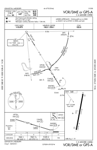
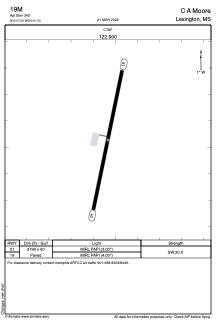
Runways:
| RWY identifier | QFU | Length (ft) | Width (ft) | Surface | LDA (ft) |
| 01 | 12° | 3199 | 60 | ASPH | |
| 19 | 192° | 3199 | 60 | ASPH |
Airport contact information
Address: Lexington United States