


0S0 - Lind
Located in Lind, United States
ICAO - 0S0, IATA -
Data provided by AirmateGeneral information
Coordinates: N46°58'37" W118°35'14"
Elevation is 1507 feet MSL.
Magnetic variation is 19° East View others Airports in Washington
Operational data
Special qualification required
Current time UTC:
Current local time:
Weather at : KMWH - Grant County Intl ( 61 km )
METAR: KMWH 041152Z AUTO 07010KT 10SM OVC100 14/00 A2961 RMK AO2 SLP024 T01390000 10156 20133 56015
TAF: KMWH 041134Z 0412/0512 07014G23KT P6SM OVC100 FM042000 08014KT P6SM OVC090 FM050000 04010KT P6SM OVC080 PROB30 0502/0506 -RA OVC060 FM050600 02009KT P6SM -RA OVC060
Communications frequencies: [VIEW]
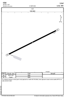
Runways:
| RWY identifier | QFU | Length (ft) | Width (ft) | Surface | LDA (ft) |
| 05 | 64° | 3197 | 50 | ASPH | |
| 23 | 244° | 3197 | 50 | ASPH |
Airport contact information
Address: Lind United States