


WIOG - Nanga Pinoh / Melawi
Located in Melawi, Indonesia
ICAO - WIOG, IATA - NPO
Data provided by AirmateGeneral information
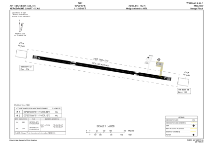
Coordinates: S0°20'56" E111°44'52"
Elevation is 132 feet MSL.
Magnetic variation is 0° East View others Airports in Kalimantan Barat
Operational data
Special qualification required
Current time UTC:
Current local time:
Communications frequencies: [VIEW]
Runways:
| RWY identifier | QFU | Length (ft) | Width (ft) | Surface | LDA (ft) |
| 10 | 99° | 3944 | 98 | ASP | |
| 28 | 279° | 3944 | 98 | ASP |
Airport contact information
Address: Melawi Indonesia