


WILL - Bandar Lampung / Radin Inten Ii
Located in Tanjung Karang City, Indonesia
ICAO - , IATA - TKG
Data provided by AirmateGeneral information
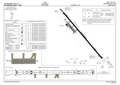
Coordinates: S5°14'26" E105°10'32"
Elevation is 273 feet MSL.
View others Airports in Lampung
Operational data
Special qualification required
Current time UTC:
Current local time:
Weather at : - ( 0 km )
METAR: YPGV 190826Z AUTO 12004KT 9999 // SCT010 SCT015 BKN027 26/25 Q1007
Communications frequencies: [VIEW]
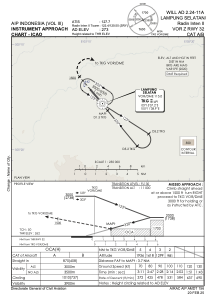
Runways:
| RWY identifier | QFU | Length (ft) | Width (ft) | Surface | LDA (ft) |
| 14 | 140° | 9088 | 148 | UNK | |
| 32 | 320° | 9088 | 148 | UNK |
Airport contact information
Address: Tanjung Karang City Indonesia