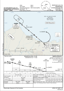
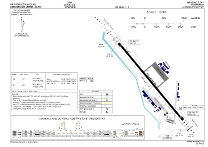


WAHS - Semarang / Jenderal Ahmad Yani International
Located in Semarang, Indonesia
ICAO - , IATA - SRG
Data provided by AirmateGeneral information
Coordinates: S6°58'35" E110°22'38"
Elevation is 13 feet MSL.
View others Airports in Jawa Tengah
Operational data
Special qualification required
Current time UTC:
Current local time:
Weather
METAR: WAHS 161900Z AUTO 10002KT 5000 NCD 28/27 Q1008
Communications frequencies: [VIEW]
Runways:
| RWY identifier | QFU | Length (ft) | Width (ft) | Surface | LDA (ft) |
| 13 | 130° | 8399 | 148 | UNK | |
| 31 | 310° | 8399 | 148 | UNK |
Airport contact information
Address: Semarang Indonesia