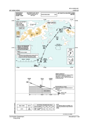


VHSS - Sheung Wan / Sky Shuttle Heliport
Situé à Hong Kong, Hong Kong
ICAO - , IATA - HHP
Données fournies par AirmateInformation générale
Coordonnées: N22°17'20" E114°9'8"
Élévation : 24 feet MSL.
Voir autres Aéroports à (unassigned)
Données opérationnelles
Special qualification required
Heure actuelle UTC:
Heure actuelle locale:
Météo à : VHHH - Hong Kong / International ( 25 km )
METAR: VHHH 291130Z 10012KT 9999 FEW025 SCT045 27/20 Q1005 NOSIG
TAF: TAF VHHH 291100Z 2912/3018 09015KT 9999 FEW020 SCT030 TX31/3006Z TN25/2922Z
Fréquences de communication: [VIEW]
Pistes:
Coordonnées de l'aéroport
Adresse: Hong Kong Hong Kong