VAC chart of LFAS
Satellite view of LFAS
image banner adimage banner adimage banner ad
image banner ad

LFAS - Falaise Monts D'eraines

Located in , France

ICAO - LFAS, IATA -

Data provided by Airmate  

General information

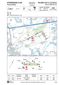
Coordinates: N48°55'37" W0°8'41"
Elevation is 513 feet MSL.
Magnetic variation is 0.24° East
View others Airports in Lower Normandy

Operational data

Special qualification required
Current time UTC:
Current local time:
Weather at : LFRK - Caen Carpiquet ( 35 km )
METAR: LFRK 131900Z AUTO 19010KT 9999 -RA //////TCU 12/09 Q1011 BECMG 21015G25KT SCT045
TAF: TAF LFRK 131400Z 1315/1324 20014KT 9999 SCT045 BECMG 1315/1318 21015G25KT TEMPO 1316/1321 -RA TEMPO 1321/1324 4000 RADZ OVC012 PROB40 TEMPO 1322/1324 2000 RADZ OVC008
View NOTAMs / SUP AIP / TFR affecting this airport [VIEW]
Communications frequencies: [VIEW]

Runways:

RWY identifierQFULength (ft)Width (ft)SurfaceLDA (ft)
0662°2789328GRASS2789
24242°2789328GRASS2789

Airport contact information

Address: France

Other aviation service providers

Aviation club (not for profit)

Aéro classic Falaise

Aéro classic Falaise

Aéroclub de Falaise

Aéroclub de Falaise
aeroclubdefalaise@gmail.com+33231900654
+33661235123

Aviation medical examiner

Dr Hurelle Gérard

Dr Hurelle Gérard
+33 231400600

Satellite view of LFAS