


YSNF - Norfolk Island
Located in Norfolk Island, Norfolk Island
ICAO - YSNF, IATA - NLK
Data provided by AirmateGeneral information
Coordinates: S29°2'33" E167°56'17"
Elevation is 371 feet MSL.
View others Airports in (unassigned)
Operational data
Special qualification required
Current time UTC:
Current local time:
Weather
METAR: YSNF 281000Z AUTO 11010KT 9999 // SCT034 SCT043 SCT053 19/13 Q1023
TAF: TAF YSNF 280503Z 2806/2906 13014KT 9999 SCT030 FM280800 13014KT 9999 -SHRA SCT025 FM290100 16014KT 9999 -SHRA SCT025 INTER 2815/2820 5000 SHRA BKN020
Communications frequencies: [VIEW]
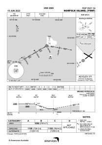
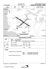
Runways:
| RWY identifier | QFU | Length (ft) | Width (ft) | Surface | LDA (ft) |
| 04 | 50° | 4708 | 98 | ASPH | |
| 22 | 230° | 4708 | 98 | ASPH | |
| 11 | 122° | 6201 | 148 | ASPH | |
| 29 | 302° | 6201 | 148 | ASPH |
Airport contact information
Address: Norfolk Island Norfolk Island