


YRID - Riddell
Located in Riddell's Creek, Australia
ICAO - YRID, IATA -
Data provided by AirmateGeneral information
Coordinates: S37°28'41" E144°43'18"
Elevation is 1155 feet MSL.
Magnetic variation is 11° East View others Airports in Victoria
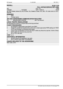
Operational data
Special qualification required
Current time UTC:
Current local time:
Weather at : YMML - Melbourne ( 24 km )
METAR: YMML 052230Z 25004KT 9999 FEW003 BKN006 11/11 Q1033 RF00.0/000.2
TAF: TAF AMD YMML 052227Z 0522/0700 23005KT 9999 BKN005 BECMG 0600/0602 18010KT 9999 SCT020 FM060400 18012KT 9999 FEW040 FM061000 19008KT 9999 FEW018 FM061500 27006KT 9999 SCT005 FM061800 27006KT 9999 SCT005 BKN010 TEMPO 0615/0700 9999 BKN005
Communications frequencies: [VIEW]
Runways:
| RWY identifier | QFU | Length (ft) | Width (ft) | Surface | LDA (ft) |
| 02 | 31° | 2686 | 28 | ASPH | |
| 20 | 211° | 2686 | 28 | ASPH |
Airport contact information
Address: Riddell's Creek Australia