


YPTN - Tindal
Located in Tindal, Australia
ICAO - YPTN, IATA - KTR
Data provided by AirmateGeneral information
Coordinates: S14°31'16" E132°22'40"
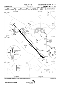
Elevation is 443 feet MSL.
View others Airports in Northern Territory
Operational data
Special qualification required
Current time UTC:
Current local time:
Weather
METAR: YPTN 021600Z AUTO 15006KT 9999 // NCD 22/16 Q1013 RF00.0/000.0
TAF: TAF AMD YPTN 021117Z 0212/0312 13006KT CAVOK FM022000 13005KT 9999 SCT015 FM030100 11016G26KT CAVOK FM030400 11014KT CAVOK FM030800 14008KT CAVOK
Communications frequencies: [VIEW]
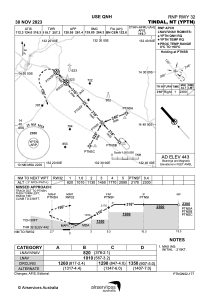
Runways:
| RWY identifier | QFU | Length (ft) | Width (ft) | Surface | LDA (ft) |
| 14 | 139° | 8996 | 148 | ASP | |
| 32 | 319° | 8996 | 148 | ASP |
Airport contact information
Address: Tindal Australia