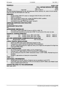


YPEF - Penfield
Located in Sunbury, Australia
ICAO - YPEF, IATA -
Data provided by AirmateGeneral information
Coordinates: S37°30'42" E144°42'1"
Elevation is 1156 feet MSL.
Magnetic variation is 11° East View others Airports in Victoria
Operational data
Special qualification required
Current time UTC:
Current local time:
Weather at : YMML - Melbourne ( 22 km )
METAR: YMML 291300Z 21007KT 9999 FEW029 BKN059 11/05 Q1028 RF00.0/000.0
TAF: TAF AMD YMML 291108Z 2912/3018 20008KT 9999 BKN035 FM291800 17008KT 9999 -SHRA BKN040 FM300200 17018KT 9999 -SHRA BKN040 FM300800 16010KT 9999 -SHRA SCT025 BKN035 FM301200 15006KT 9999 NSW BKN035
Communications frequencies: [VIEW]
Runways:
| RWY identifier | QFU | Length (ft) | Width (ft) | Surface | LDA (ft) |
| 18 | 0° | 4035 | 98 | G | |
| 36 | 0° | 4035 | 98 | G | |
| 15 | 0° | 2461 | 98 | G | |
| 33 | 0° | 2461 | 98 | G | |
| 00 | 14° | 3991 | 47 | GRAS |
Airport contact information
Address: Sunbury Australia