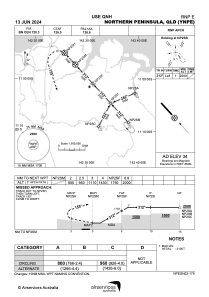
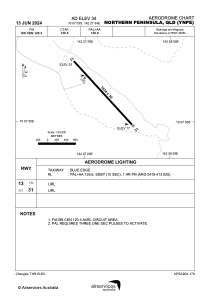


YNPE - Northern Peninsula
Located in Bamaga, Australia
ICAO - , IATA - ABM
Data provided by AirmateGeneral information
Coordinates: S10°57'3" E142°27'34"
Elevation is 34 feet MSL.
View others Airports in Queensland
Operational data
Special qualification required
Current time UTC:
Current local time:
Weather at : YHID - Horn Island ( 45 km )
METAR: YHID 020230Z AUTO 12019KT 9999 // BKN022 BKN028 31/26 Q1008
TAF: TAF YHID 012310Z 0200/0300 12020KT 9999 -SHRA SCT018 FM020800 13014KT 9999 -SHRA FEW012 SCT015 FM022100 14016KT 9999 NSW FEW025 SCT040 INTER 0200/0223 12020G30KT 2000 SHRA BKN006 FEW020TCU
Communications frequencies: [VIEW]
Runways:
| RWY identifier | QFU | Length (ft) | Width (ft) | Surface | LDA (ft) |
| 13 | 137° | 6017 | 98 | UNK | |
| 31 | 317° | 6017 | 98 | UNK |
Airport contact information
Address: Bamaga Australia