


YKII - King Island
Located in Currie, Australia
ICAO - YKII, IATA - KNS
Data provided by AirmateGeneral information
Coordinates: S39°52'39" E143°52'42"
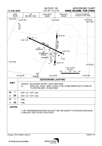
Elevation is 132 feet MSL.
View others Airports in Tasmania
Operational data
Special qualification required
Current time UTC:
Current local time:
Weather at : - ( 0 km )
METAR: KQFX 270110Z AUTO 19003KT 9999 BKN080 BKN0100 BKN140 30/25 A2999 RMK A02 TSNO
Communications frequencies: [VIEW]
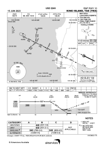
Runways:
| RWY identifier | QFU | Length (ft) | Width (ft) | Surface | LDA (ft) |
| 10 | 115° | 5200 | 98 | ASP | |
| 28 | 295° | 5200 | 98 | ASP | |
| 17 | 184° | 3625 | 98 | COM | |
| 35 | 4° | 3625 | 98 | COM |
Airport contact information
Address: Currie Australia