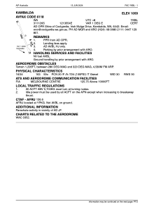


YKBL - Kambalda
Located in Kambalda, Australia
ICAO - YKBL, IATA - KDB
Data provided by AirmateGeneral information
Coordinates: S31°11'24" E121°35'52"
Elevation is 1059 feet MSL.
Magnetic variation is 1° East View others Airports in Western Australia
Operational data
Special qualification required
Current time UTC:
Current local time:
Weather at : YPKG - Kalgoorlie-Boulder ( 46 km )
METAR: YPKG 271530Z AUTO 23007KT 9999 // NCD 17/08 Q1020 RF00.0/000.0
TAF: TAF YPKG 271113Z 2712/2812 32006KT CAVOK FM271500 22006KT CAVOK FM280100 16008KT CAVOK
Communications frequencies: [VIEW]
Runways:
| RWY identifier | QFU | Length (ft) | Width (ft) | Surface | LDA (ft) |
| 16 | 164° | 5905 | 98 | X | |
| 34 | 344° | 5905 | 98 | X |
Airport contact information
Address: Kambalda Australia