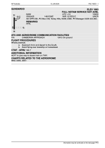


YGDO - Gundaroo
Located in Terrey Hills, Australia
ICAO - YGDO, IATA -
Data provided by AirmateGeneral information
Coordinates: S35°2'42" E149°15'30"
Elevation is 1901 feet MSL.
View others Airports in Northern Territory
Operational data
Special qualification required
Current time UTC:
Current local time:
Weather at : YSCB - Canberra ( 30 km )
METAR: YSCB 021000Z AUTO 12006KT 9999 // SCT021 10/07 Q1032 RF00.0/000.0
TAF: TAF YSCB 020827Z 0209/0306 10008KT 9999 SCT035 FM021000 13006KT 9999 SCT015 FM030000 10010KT 9999 SCT025 FM030300 09010KT 9999 -SHRA SCT030 TEMPO 0212/0300 9999 BKN015
Communications frequencies: [VIEW]
Runways:
| RWY identifier | QFU | Length (ft) | Width (ft) | Surface | LDA (ft) |
| 18 | 0° | 0 | 0 | UNK | |
| 36 | 0° | 0 | 0 | UNK | |
| 09 | 0° | 0 | 0 | UNK | |
| 27 | 0° | 0 | 0 | UNK |
Airport contact information
Address: Terrey Hills Australia